Arader Galleries

CHATELAIN. Carte Tres Curieuse ...1719
$ 35,000.00
Pickup currently unavailable
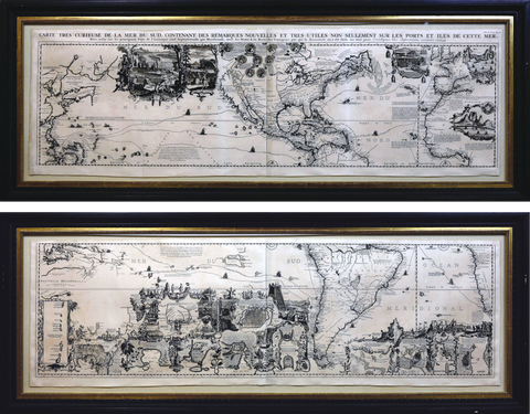
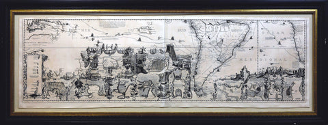
CHATELAIN, Henri Abraham (1684-1743).
Carte Tres Curieuse de la Mer du Sud.
Engraved map.
Amsterdam, 1719.
17 3/4” x 56 1/2” sheet, 24” x 63” framed.
Wonderful large map of North and South America, with California pictured as an island. Based upon a larger but otherwise very similar map by Nicolas De Fer published in 1718, Chatelain’s map appeared in the sixth volume of his landmark Atlas Historique.The map provides an amazing graphical depiction of the age of discovery and the character of the New World. The map is embellished with more than 35 insets and vignettes of various scenes and regions in the New World. Nine medallions at the top center portrayed important explorers including Columbus, Vespucci, Magellan, Drake, and Dampier, while the tracks of their voyages were marked on the map.The marginal vignettes range from narrative scenes depicting colonial economies based on beaver, cod, and sugar to geographic insets providing large-scale maps of significant locations, such as the Mississippi delta, Niagara Falls, the Cape of Good Hope, as well as numerous cities and towns. Although California was depicted as an island on this map, there was a notation indicating that some Europeans believed it was attached to the mainland, making this one of the first European maps to question the myth of California as an island as depicted on many Dutch and English maps since the 1630s (Schwartz / Ehrenberg, 85).