Arader Galleries

Map of Asia
$ 18,000.00
Pickup currently unavailable
Jean Baptiste Louis Abbé Clouet (1730 - 1790) & Louis Joseph Mondhare
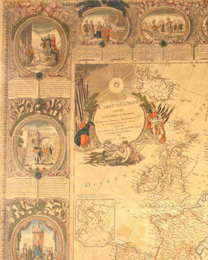
Carte D'Asie Divisee en ses principaux Etats . . .
Paris, 1788
Hand-colored copper plate engraving
Framed to Full Museum Specifications: 53 x 42 inches
$18,000
The Clouet / Mondhare wall map of Asia is one of the most decorative wall maps of Asia published in the second half of the 18th Century. The map continues the French Aristocratic tradition popularized during the reign of Louis XIV. In this grand tradition, the Clouet / Mondhare map serves the dual purpose of being both a spectacular object, utilized by the French Aristocracy of the 18th Century, in decorating libraries and salons, and a statement of the worldliness of the owners.
The map includes 20 decorative vignettes of various scenes from around Asia. The cartographic content of the map reflects Clouet's intention to compile a map of the highest quality.
The map includes a detailed inset and the tracks of the route of the "Gore" expedition in 1779 (identified as successor to Clerke), a reference to James Cook's Third Voyage. For Cook's third expedition, Charles Clerke was placed in command of HMS Discovery. When Cook was killed in a skirmish with Hawaiians on February 14, 1779, Clerke took command of the expedition and of HMS Resolution. He continued the expedition's exploration of the Northern Pacific coast, searching for a navigable Northwest Passage. The expedition then proceeded to the Pacific coast of Siberia. Lieutenant James King, one of his subordinates, wrote that Clerke's illness had reduced him to skeletal thinness. Clerke died from tuberculosis on August 22, 1779, en route to Kamchatka from the Bering Strait. He was buried in Kamchatka on August 29, 1779. Clerke's second in command, Lieutenant John Gore took command of the expedition as captain of Resolution, appointing King as captain of Discovery. The expedition then sailed via China and the Sunda Strait to Cape Town, returning to England in August 1780.
The map shows Clouet as a member of the "Academie Royale des Sciences de Rouen. The Académie des Sciences, Belles-Lettres et Arts de Rouen was created in the City of Rouen, in France, by order of Louis XV in 1744 and existed until 1793. It was briefly supressed during the Repubican era, and then re-established in 1803.
A striking, finely colored example of this decorative map.