Arader Galleries

Map of Europe
$ 15,000.00
Pickup currently unavailable
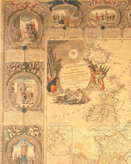
Jean Baptiste Louis Abbé Clouet (1730 - 1790) & Louis Joseph Mondhare
Carte D'Europe Divisee En ses Empires et Royaumes…
Paris, 1788
Hand-colored copper plate engraving
Framed to Full Museum Specifications: 53 x 42 inches
A large and impressively decorative wall map of Europe by Jean Baptiste Louis Clouet. Clouet's map covers all of Europe from Spain to the Ural Mountains and from Nova Zembla and the Arctic Ocean to North Africa, Turkey, and Persia. It includes the Black Sea, and adjacent parts of Asia. The map proper is surrounded by twenty vignettes illustrating important moments in European history as well as various monarchs. Beneath each vignette is a short paragraph of explanatory text in French and Spanish.
This map was issued on the cusp of world changing events. The American Revolution had just ended and by the end of the century would spread its egalitarian ideals to Europe - most specifically France. In the meantime Clouet paints a picture of Europe dominated by the remnants of feudalism. Kings in France, Spain, England, and Portugal, while central Europe remained a loose coalition under the Holy Roman Empire. Poland, though in longer period decline under the Commonwealth, still claimed vast expanses of territory from the Baltic to the Black Sea. Russia meanwhile was pushing across the continent as far as China and Siberia. Italy, though here color coded as a single country, was in fact an amalgam of independent princedoms, duchies, and republics. This largely untenable system would soon breakdown into the French Revolution and Napoleonic Wars - the growing pains of a new world order.