Arader Galleries


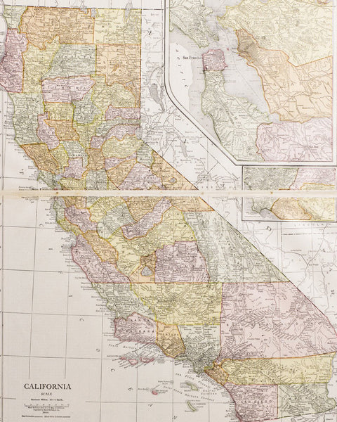
Colton's Map Of The States And Territories West of the Mississippi River
$ 30,000.00
Pickup currently unavailable
The Finest Reconstruction Period Pocket map of the West
Colton, J.H. (1800-1893)
Colton's Map Of The States And Territories West of the Mississippi River
New York: 1864 - FIRST EDITION
Hand Colored Lithograph, pocket map
Paper Size: 29 1/2”x 41” ; Framed Dimensions: 34 1/4” x 46
$30,000
The best pocket map of the west from the Reconstruction period.
This very detailed map of the Transmississippi West notes railroads, cities, towns, routes, mines, forts (indicated with a tiny US flag), ruins, Indian lands, lakes, mountains, and rivers. One small note in western Texas states ‘Rolling Prairies and very Fertile’. The map also shows the strip of land above Texas labeled "Public Lands," which would become the Oklahoma Panhandle. Also includes detailed treatment of Indian Territory, showing the lands reserved for the various Indian Nations relocated to the region.
This map was reproduced as an informative map for the post-Civil War traveler. It shows explorer tracks such as Fremont and Emory, existing and proposed rail lines and trails such as Mallans Wagon Road [Ft. Benton-Prickly Pear City (Mont.)]. Proposed National Railway Co. Line snakes through Albuquerque and northern Arizona. Proposed Texas Pacific R.R. goes through southern Arizona via San Xavier rather than Tucson. Gadsden Treaty purchase still shown. Denver has an active railroad in three directions and a proposed one south to Santa Fe. Note in Taylor County in Texas says, "healthy and very fertile rolling table lands". Proposed new railroads all over Texas. Just west of Marshall and south of Corsicana are the closest completed lines to Dallas. Forts and army camps marked with large American flags. Superb detail of Indian villages and tribes, gold mines, copper and silver mines, and topography.