Arader Galleries

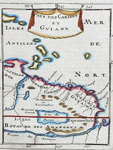
Le table neufues lefquells on appelle isle d’occident & d’Indie pour divers regard
$ 11,000.00
Pickup currently unavailable
Sebastian Münster (1488-1552)
“Le table neufues lefquells on appelle isle d’occident & d’Indie pour divers regard”
From Ptolemy’s Geographica
Basle: [1540] 1552
Woodcut engraving
11 ½" x 15"; 23" x 26 ½" framed
$11,000
In 1540, Basel-based cartographer Sebastian Münster published a groundbreaking edition of Ptolemy’s Geography, based on the Latin translation of Willibard Pirckheimer, that included this important early map devoted exclusively to the New World. Stretching from Greenland down the coast of Newfoundland to Florida and the Caribbean (with “Cuba” distinctly labeled), and as far south as the Strait of Magellan, the map includes corners of Asia, Europe and Africa, but emphasizes the notion that the recently discovered landmasses are a distinct entity: a truly New World as opposed to a part of Asia, as many previous geographers believed. When Münster included this map in a second publication, his great Cosmographia universalis (first published 1540), he introduced his concept of the New World to an international public. The book, ultimately translated into five languages and published in dozens of different editions, proved to be one of the most influential works dealing with geography in the sixteenth century, and Münster’s map became the most widely circulated contemporary delineation of the New World until the publication of
Ortelius’s atlas in 1570. This particular version of Münster’s Americas map was published in the 1552 French text edition.
Münster’s map is a revealing lens onto contemporary geographical ideas about the Americas. The eastern coastline, although distorted in places, is remarkably recognizable considering that fewer than fifty years had transpired since Columbus’s first voyage. The dearth of knowledge regarding the vast inland regions is reflected in the lack of detail other than conventional symbols for mountains and forests. The outline of South America is based on recent information gleaned from the discoveries of Magellan, a source that Münster acknowledged by depicting the explorer’s ship in the Pacific Ocean.
Münster, a native of Ingelheim near Mainz in Germany, studied Hebrew at Heidelberg and became an eminent professor in that field as well as a scholar of geography. He was also an innovator in the technological development of map printing. In the sixteenth century the printing of image and text together was still a particular challenge, and Münster was one of the first to create space for the insertion of place-names in metal type within the woodblocks used to print his maps. Münster’s most significant contribution to the history of cartography, however, was this map, which provides a rare glimpse into changing perceptions of the New World.