Maps of the Hawaiian Islands
A selection of Maps of Hawaii
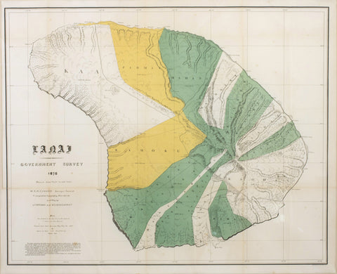
In 1871, King Kamehameha V appointed William De Witt Alexander as the kingdom's first surveyor-general, with a mandate to conduct 'the Hawaiian Government Survey', a Herculean endeavour to map all of the major islands in a systematic manner, employing the most advanced techniques and equipage. Alexander, who was of American extraction, but born in Honolulu, was one of Hawaii's brightest lights, and in addition to his cartographic endeavours, was an esteemed historian, writer and scientist. In spite of the fact that he was given meagre financial resources and was operating in a land so isolated from major centres, he was able to assemble a first-rate team of surveyors. Over the next decade he led his parties to conduct exacting triangulated surveys of all of the main islands, seemingly undaunted by the outrageous obstacles posed by the extreme topography and the dense foliage of the jungles. F.S. Dodge compiled their various manuscript district maps into the first accurate, modern general maps of each island, which were first published between 1878 and 1885.
Since the first edition of the Alexander map of Maui was published in 1885, the island had undergone
transformative change. The vast royal estates and government holdings which had comprised most of the island had been largely dissolved and granted or sold off to become vast agricultural plantations owned by mainland Americans. Towns such as Lahaina, Wailuku and Kahului had greatly expanded, and from 1900 to 1906, it is estimated that the island's population had grown from around 25,000 to over 35,000. Government officials and landowners urgently needed a new, updated version of the Alexander map.
Alexander, who was still serving as Hawaii's surveyor-general, dispatched teams led by his deputy, John Donn, to chart the new nature of the island's landscape, a task completed in 1903. The present new and improved edition of the Alexander Maui map was printed in 1906, and accompanied the Governor of the Territory of Hawaii, George R. Carter's annual report to the U.S. Secretary of the Interior.
the various divisions of the island are illuminated in resplendent color, entirely appropriate to the depiction of a tropical paradise. The island's varied topography is elegantly expressed by precise patterns of hachures, notably the awesome chasm of the Io Valley, long sacred to native Hawaiians, and the vast crater of the Haleakala massif, which rises to over 10,000 feet. The various stations used by the surveyors to create their web of interconnected triangulated sight-lines are marked by the symbol of a 'triangle'. The mid-section of the island, extending from Kahului in the north down towards Makena in the south, is dominated by vast new land grants, most of which were sugar plantations. Government lands recently sold off are designated by the acronym 'Gt.', while lands grated to patentees by the territorial Land Commission are designated by 'Aw'. Lahaina, which was experiencing rapid growth, is the most prominent town on Maui, while, with the exception of the district of Hana, the rugged eastern half of the island is shown to have undergone only very limited development. Alexander's Maui map was widely admired by his peers on the mainland for its accuracy and exquisite appearance, and it remained the authoritative map of the island for many years.
References: Library of Congress: G4382.M3 1885 .D6 (1885 edition); David Rumsey Map Collection (online): no. 3705.006. cf. [Governor George R. Carter], Report of the Governor of the Territory of Hawaii to the Secretary of the Interior (Washington, D.C.: Government Printing Office, 1906), see esp. pp.74-78, referring to the 'Surveying Department' of Hawaii.
Subscribe to our newsletter:
Location
Arader Galleries
1380 Main Street
Saint Helena, CA 94574
Hours
Monday - Friday: 9 am to 5 pm
Saturday - Sunday: 11 am to 5 pm
For any inquiries you can reach the gallery through phone or email:
Tel: 707-225-4571
Email: josephine.arader@gmail.com
Copyright © 2025 Arader Galleries. Powered by Shopify