Arader Galleries
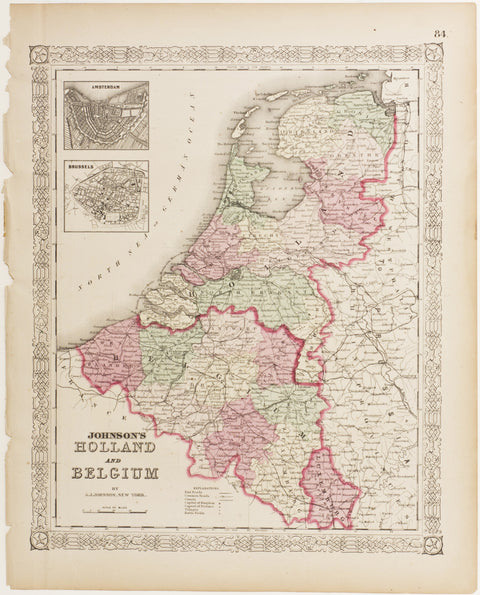
Johnson's Holland & Belgium
$ 30.00
Pickup currently unavailable
A.J. Johnson (1827 - 1884)
Johnson's Holland & Belgium
From: Johnson's New Illustrated Family Atlas
New York; ca. 1864
Original hand-colored lithograph
Sheet Dimensions: 14.5 x 18.25 in.
A detailed and colorful map of Holland & Belgium. Including insets of Brussels and Amsterdam.
Alvin J. Johnson entered into the business of publishing atlases in 1860. Having previously been a book canvasser who sold maps and atlases for the well-known map and atlas publisher, J.H. Colton, Johnson was introduced to the profitability of atlases as a reference book. When he came to New York City in 1857, he began to support Colton in the publishing of his atlases and maps. In 1859, Colton’s General Atlas was published by the firm of Johnson & Browning, and the next year he published the first edition of his own atlas, titled, Johnson’s New Illustrated (Steel Plate) Family Atlas, With Descriptions Geographical, Statistical and Historical. The early editions of the Family Atlas, as it is most commonly referred to, was comprised of maps developed by the Colton firm, and the title page announces that the publishers, Johnson & Browning, are “formerly (successors to J.H. Colton and Company…” However, rather than successor, Johnson became a competitor of the Colton firm, and the Family Atlas became a competitor to the atlases of both Colton and S. Augustus Mitchell, the other prominent atlas publisher of the day.