Arader Galleries
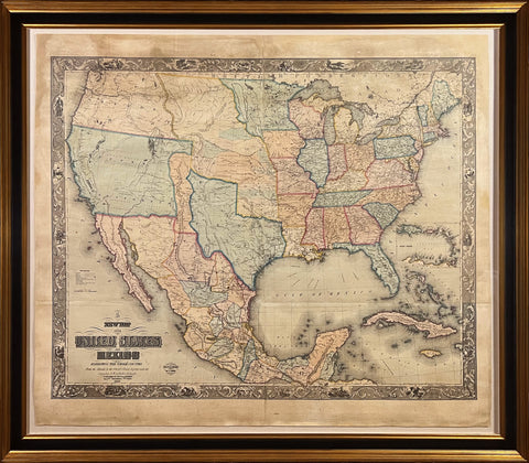
Doolittle & Munson, New Map of the United States and Mexico....1849
$ 14,000.00
Pickup currently unavailable
Doolittle & Munson
New Map of the United States and Mexico exhibiting the whole country from the Atlantic to the Pacific Ocean together with the Canadas and West India Islands.
Cincinnati, Ohio : Monk & Sherer, 1849.
Hand-Colored Lithograph
Paper size 51-3/4“ wide x 44-1/2“ high -Outside frame size 59” wide x 51-3/4” high
This 1847 (republished in 1849) map was produced during the Mexican-American War. At that time the Treaty of Cahuenga had just ended the conflict in California. John C. Fremont was installed as that state’s first governor in January of 1849.
One year later with the signing of the Treaty of Guadalupe Hidalgo the war was finally ended. In the war's wake, the United States gained vast areas of land including New Mexico, Arizona, Nevada, Utah, and portions of Colorado and Wyoming. In 1847 Brigham Young and his Mormon followers reached the Salt Lake Valley of Utah. This map was drawn and engraved by Doolittle & Munson and published by Monk & Sherer in 1847. It shows railroads, canals, waterways, main roads, common roads, cities, towns, and villages. Places on the Oregon and Santa Fe routes are noted along with locations of battles in Mexico. Included are several informational explanations.