Arader Galleries


Pruess. The Oregon Trail. 1846
$ 9,000.00
Pickup currently unavailable
From "A Report of the Exploring Expedition to Oregon and California"
PREUSS, Charles (1803-1854).
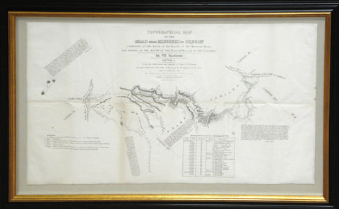
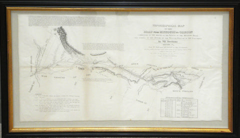
Topographical Map of the Road from Missouri to Oregon Commencing at the Mouth of the Kansas in the Missouri River and Ending at the Mouth of the Wallah Wallah in the Columbia.
From the field notes and journal of Capt. J. C. Frémont.
Baltimore: E. Weber &Co., 1846.
Framed dimensions: 20" x 30" each
One map on 7 lithographed sheets
The celebrated cartographer Charles Preuss first issued a map of this area to accompany Fremont s "A Report of the Exploring Expedition to Oregon and California" (1845).
Fremont's report, written with the help of his wife Jessie Benton, and Preuss’s map "changed the entire picture of the West [and] represented an important step forward from the earlier western maps of the period as did those of Pike, Long, and Lewis and Clark in their day. [Preuss's map] represented trustworthy direct observation, a new, welcome, and long overdue development in the myth-encrusted cartography of the West.
This map marked not only the end but the beginning of an era" (Wheat). The Frémonts' account of the journey, A Report of the Exploring Expedition to Oregon and California . . . (1845), enthralled the nation. Skillfully combining adventure, scientific data, and detailed practical information for emigrants, supplemented by a valuable map prepared by expedition cartographer Charles Preuss, it was "monumental in its breadth--a classic of exploring literature" (William H. Goetzmann, Exploration and Empire [1966], p. 248).
This new, and much enlarged map was commissioned by the Senate of the United States, and reproduces the area in much greater detail. It "was a road guide for Oregon emigrants such as had never previously existed. The purview of each section is quite narrowly limited to the emigrant road, but the topography is developed in rather more detail than on the parent map.
Owing to its rarity and to its having long stood in the shadow of the much more widely known and distributed Fremont map of 1845, Preuss's sectional map of 1846 has been insufficiently appreciated by students of Western history." (Wheat). The individual sections of this magnificent map are:
Section I: The map begins in the east at Westport, Kansas (now known as Kansas City), the departure point for the Oregon Trail, and ends in southern Nebraska at the crossing to Platte river. The "Remarks" on the maps state: "This section abounds with grass, water and fuel so that emigrants may encamp almost anywhere. (3). Elk and deer, the only game, are very scarce."
Section II: Begins near present-day Marquette, Nebraska, and goes as far as present day Ogallala, Nebraska. The "Remarks" state that "Timber is extremely scarce., except on the islands. Some driftwood and Buffalo excrement makes the fuel, as that of the camels does in the deserts of Arabia". Several quotes from Fremont's report are included in the margins: "Buffalo swarming in immense numbers over the plains, where they had left scarcely a blade of grass. Indians and buffalo make the poetry and life of the prairie, and our camp was full of their exhilaration".
Section III: Begins near Sidney, Nebraska (near the Colorado border), and goes to what is now Casper, Wyoming. Remarks state that the "Sioux Indians are not to be trusted". Fort Laramie is shown, and the remarks point out that there is very little game to 50 miles either side of the station: "If it is in contemplation to keep open the communications with Oregon Territory, a show of military force in this country is absolutely necessary and a combination of advantages [sic] renders the neighborhood of Fort Laramie the most suitable place on the line of the Platte for the establishment of a military post".