Arader Galleries


Ensign & Thayer. Map of the Gold Regions of California...1849
$ 16,000.00
Pickup currently unavailable
An significant Map in the History of the California Gold Rush
Ensign & Thayer
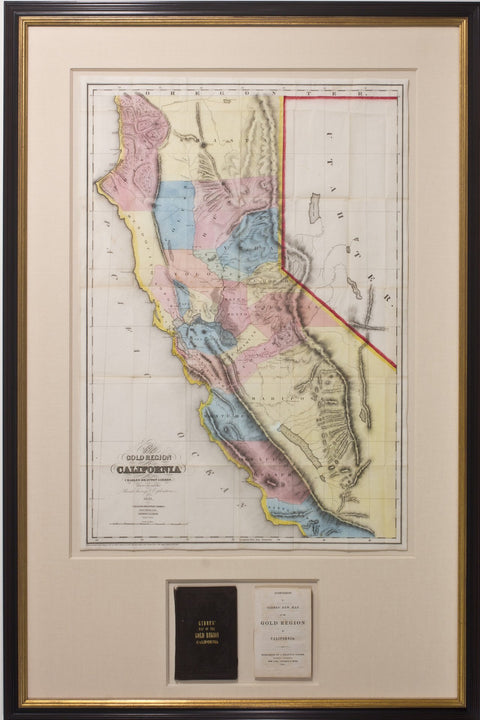
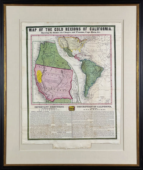
Map of the Gold Regions of California, Showing the Routes via Chagres and Panama, Cape Horn...
Hand-colored lithograph
Framed size: 35 1⁄2" x 30"
Sheet size: 26 1⁄4" x 20 3⁄4"
New York: Ensign & Thayer, 1849
Literature: Carl I. Wheat, The Maps of the California Gold Region, 1848-1857, pg. 85
This vibrant map is a significant and extremely rare document of the California Gold Rush. Published in 1849, it offered prospective gold seekers all of the information necessary to make the arduous trek to the West Coast. Indeed, arriving in San Francisco safely was no easy feat during the mid-nineteenth century. Early pioneers, called “forty-niners,” traveled to California either by ship (often choosing to sail around the entire South American continent) or across North America in covered wagons. Both of the various overland and sea routes to California are illustrated on Ensign & Thayer’s extraordinary and thorough map.
In addition to showing the principal routes to California, Ensign & Thayer’s map also features a stunning ornamental border and includes two text boxes: “Important Directions to Persons Emigrating to California” and “Description of California, or the new Gold Region.” The second of the two texts concludes with the following laudatory statement: “Such is California - the richest, most picturesque and beautiful region, for its extent, upon the face of the earth. Such is the El Dorado of the Gold mines; and such is the great acquisition of the late war with Mexico.” Some cartographic scholars believe that Ensign & Thayer’s map, though first published separately in 1849, was later folded into numerous copies of Thomas Jefferson Farnham’s Life, Adventures, and Travels in California (1857, a copy of this is included with the map).
The California Gold Rush commenced on January 24, 1848, when gold was discovered at Sutter’s Mill in Coloma, California. News of the discovery spread quickly. In time, 300,000 people made their way to the West Coast. Such gold seekers originated from the United States, Latin America, Europe, Australia and Asia. As a result, scholars refer to the situation in California as the first truly international gold rush.
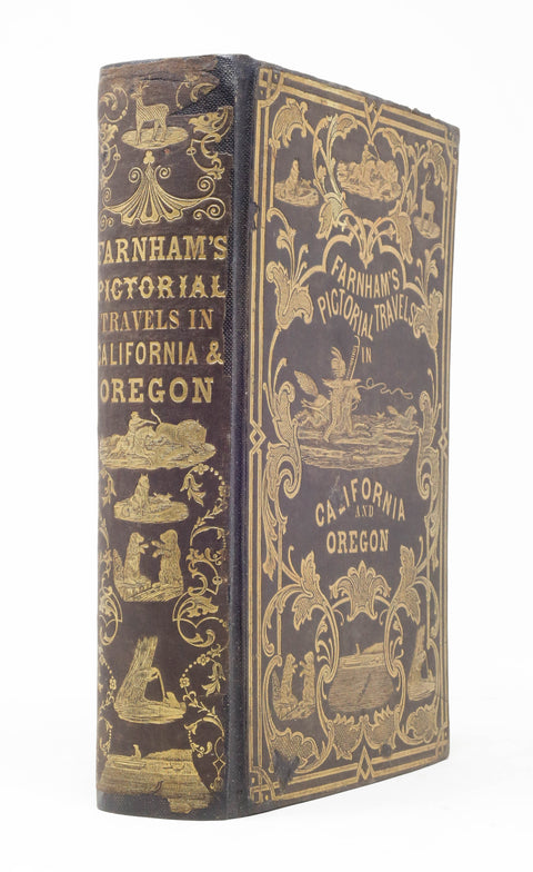
First "Pictorial Edition!!!" New York: Published by Nafis & Cornish. St. Louis, Mo.: Van Dien & Macdonald; 1849. Quarto (9 1/16" x 5 11/16", 230mm x 144mm). [Full collation available.] With a wood-engraved frontispiece, title-page and 51 wood-engraved plates (one double-sided); included in the foliation but not in the pagination. With a hand-colored wood-engraved folding map "United States and Mexico Including Oregon, Texas and the Californias" (ca. 1849, perhaps introduced to the volume). Bound in the publisher's black gilt pictorial cloth (rebacked, with the original backstrip laid down). Rebacked, with the original backstrip laid down. Wear to the upper edge of the front board. Very occasional soiling, and a very mild even tanning. Map attached to a new stub. Ownership signature in ink of "Edwd Slevin/ Dec 24th 1849" to the recto of the first free end paper and to the recto of the final binder's blank (date "Dec 24. 1849"). Inkstamp of P. R. Cain, St. Louis to the front paste-down. Thomas Jefferson Farnham (1804-1848) was a New Englander who heard the call of the West. He joined a mission to Oregon and became the captain of the Oregon Dragoons, the militarized embodiment of the Peoria Party that set out in 1839 to drive out the English fur-traders and to colonize Oregon territory (from the present Oregon/California border nearly to Alaska along the Pacific coast) for the United States. They blazed the Oregon Trail and were eventually instrumental (Farnham in particular) in the annexation of the territory. From 1842 he published accounts of the West that electrified America and Britain. In 1844 he published his Travels in California, which form the kernel of the present item. Farnham died in 1848 but his work continued undimmed; as the treble-exclamation announcing the pictorial edition indicates, there was great demand for visual accounts of the Wild West. This illustrated edition is also the first to contain an account of the gold-producing parts of California, doing its part in driving the Gold Rush of 1849. The map (Wheat, Transmississippi 513) is a hybrid of Wheat California Gold Region 26 (Haven, New York 1846) and 47 (Journal of Commerce, New York 1848) and is unsourced (Wheat sub 26: "apparently published in an atlas of the period."). Although often found in copies of the present item, it should not be thought as indigenous to it. The coloring is executed by hand, but the red boundary outlines appear to be printed from a separate plate (offset upwards by about 2mm). This map is quite rare, and crucial as a document of the Gold Rush. Of Edward Slewin who signed the book on Christmas Eve in the year of publication, or of P.R. Cain of St. Louis (perhaps an osteopath?), nothing can be stated. Bradford 1630, Braislin 718, Cowan II p. 203, Garret Mexican-American War 147, Howes F49, Sabin 23868, Wagner-Camp-Becker 107:6, Wheat California Gold Region 26/47 (map), Wheat Transmississippi 513 (map).