Arader Galleries
Abraham Ortelius. Hispaniae Novae Sivae Magnae Recens Et Vera Descriptio 1579.
$ 850.00
Pickup currently unavailable
Abraham Ortelius (1527–1598)
Hispaniae Novae Sivae Magnae Recens Et Vera Descriptio 1579
From Theatrum Orbis Terrarum, Antwerp, 1579
Copperplate engraving
Sheet Size: 22.5 x 17.75
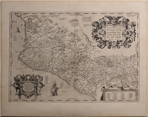
A foundational map of New Spain, Ortelius’ depiction of Mexico is one of the earliest printed maps of the region. This detailed representation includes newly established Spanish settlements, rivers, and significant lakes, including Lake Chapala. Notably, a mythical northwest sea with islands appears, reflecting European speculation about the geography of the Americas.
The map’s elaborate ornamentation features a striking title cartouche in the upper right, adorned with interwoven motifs, somber faces, and a devilish figure at the center. The title translates to, “A recent and true representation of new or large Spain 1579.” A secondary cartouche in the lower left notes Ortelius’ departure from the traditional Ptolemaic longitude, marking it instead from the Spanish meridian in Toledo. This reflects a broader shift in cartography, as Ortelius’ Theatrum Orbis Terrarum was the first modern atlas, breaking from medieval geographic conventions.
Rich with place names, the map includes so many locations that some are referenced by lettered keys in the surrounding seas. Spanish military encampments, marked with distinctive symbols, highlight the colonial expansion. Textual annotations describe indigenous peoples, sometimes in exaggerated and sensationalized terms, reinforcing the European perception of the Americas as wild and untamed. Scholars debate Ortelius' sources, but it is likely that he drew upon Jean Duran’s 1575 map of Mexico and various Spanish travel accounts.
As one of the first printed maps of New Spain, Ortelius’ work was instrumental in shaping European conceptions of the Americas. Its publication in Theatrum Orbis Terrarum—which saw 31 editions in seven languages between 1570 and 1612—ensured its wide circulation and lasting influence. Present in 20 subsequent editions, including the 1606 English edition, this map remains a defining image of Spanish America during the late sixteenth century.
A significant cartographic artifact, this example of Ortelius’ Americae sive Novi Orbis is a testament to the early European visualization of the New World, blending geographic knowledge, artistic embellishment, and colonial ideology.