Arader Galleries
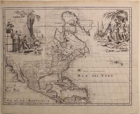
Guillaume Delisle. America...1752.
$ 850.00
Pickup currently unavailable
Guillaume Delisle (1675–1726)
America, das Mitternächtige, nach der Zeichnung des Herrn Wilhelm Delisle
Published by Johann Justin Gebauer, Halle, 1752
Copper plate engraving
Paper Size: 13.25 x 17 inches
This map, based on the work of Guillaume Delisle, captures a critical moment in North American history. By 1752, European powers—France, Britain, and Spain—were locked in a struggle for dominance over the continent. Just two years later, tensions would erupt into the French and Indian War (1754–1763), reshaping colonial boundaries and paving the way for the American Revolution.
Delisle was one of the first cartographers to use astronomical observations to improve map accuracy, correcting earlier myths like the imagined Sea of Verrazano. His work redefined how the Mississippi River, the Great Lakes, and key colonial territories were understood. This 1752 German edition, published by Johann Justin Gebauer, reflects the widespread demand for Delisle’s maps across Europe, where accurate geography was essential for military strategy, trade, and diplomacy.
At a time when maps were not just tools but weapons in imperial conflicts, this engraving provided a clearer picture of North America’s contested lands. It is a remarkable artifact from an era when geography shaped history.