Arader Galleries
Willem Bleau. Nova Hispania et Nova Galicia. 1635.
$ 550.00
Pickup currently unavailable
Willem Blaeu (1571–1638)
Nova Hispania et Nova Galicia
From Theatrum Orbis Terrarum, sive Atlas Novus, Amsterdam, c. 1636
Hand-colored copperplate engraving
Sheet size: 15.0 x 19.5 inches (38.1 x 49.5 cm)
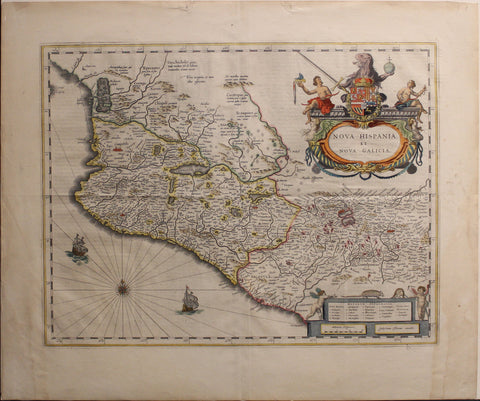
A stunning cartographic depiction of Mexico in the early 17th century, Nova Hispania et Nova Galicia by Willem Blaeu extends from just north of Mazatlán to Acapulco and from Tehuacán to the Sierra Madre mountains. It highlights key cities of the era, including Mexico City, Puebla (Angelorum Civitas), Colima, Compostela, Purificación, and Michoacán. Blaeu’s meticulous engraving provides an invaluable glimpse into the geography, settlements, and administrative divisions of New Spain during the height of Spanish colonial rule.
This map is celebrated for its exquisite decorative elements. The elaborate title cartouche, adorned with allegorical figures and heraldic arms, reflects Blaeu’s signature artistry. Additional embellishments, including sailing ships, a compass rose, and a smaller cartouche, enhance the map’s aesthetic appeal while emphasizing the maritime and commercial significance of the region. The Notarum Explnatio section details important locations such as Escalpucoleo, Gucytitlan, Xiquicpico, Veicilapa, Ocellotepec, Mimiapa, Caltoca, Chiconantla, Thecheistlan, Tapaleapan, Itapalapa, Mexicalcingo, Catlavaca, and Chalcontengo, contributing to a more comprehensive understanding of the colonial landscape.
Beyond its artistic beauty, this map holds immense geopolitical significance. Published at a time when Spain’s dominance in the Americas was at its peak, it reflects the strategic and economic importance of New Spain in the global trade network. Mexico was the linchpin of Spain’s empire, serving as the conduit for silver exports that financed European wars and as a critical hub in the transpacific Manila Galleon trade. Blaeu’s work, produced in Amsterdam during the Dutch Republic’s struggle against Spanish rule, also underscores the era’s competition for maritime supremacy and territorial influence.