Arader Galleries
A New Map of Texas, Oregon and California
$ 14,000.00
Pickup currently unavailable
Samuel Augustus Mitchell (1792-1868)
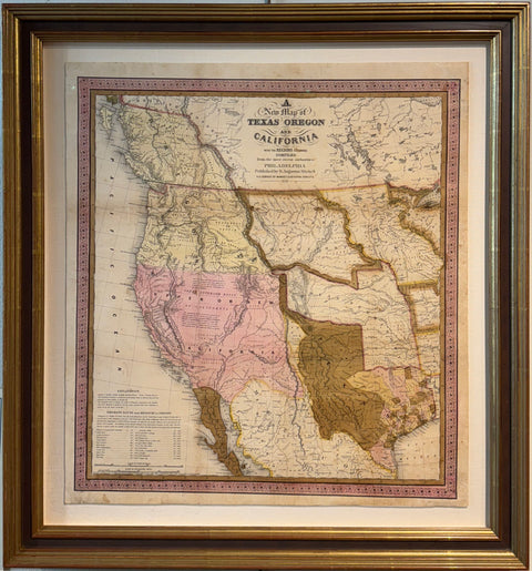
A New Map of Texas, Oregon and California
Published by Thomas Copperthwait Philadelphia, 1846
Paper size: 24 " x 22 " Frame: 28" x 29 "
Framed to Full Museum Specifications
Samuel Augustus Mitchell's map, covering Texas, Oregon, Upper California, Missouri, and a vast Indian Territory, serves as an essential record of a pivotal moment in Western American history marked by substantial territorial shifts and escalating conflicts. This consequential map weaves together intricate narratives of geography, politics, and culture, offering an indelible portrait of the mid-19th-century American West.
During this period, the mapped region was under intense scrutiny due to the recent admission of Texas into the Union in 1845, leading to the Mexican invasion of Texas and the subsequent U.S.-Mexican war in 1846. The map emerged in response to these events, providing a geographically comprehensive picture of the contested territories during a moment of profound transition. Mitchell's reliable sources, including Arrowsmith's map of Texas and data from Lewis & Clark's expedition, imbued the map with an authenticity that enhanced its appeal during a period of heightened interest in these regions.
The map holds the distinction of having been used by significant historical figures and groups. One notable user was Brigham Young, leader of the Latter-Day Saint movement, who ordered six copies of this map. Notably, an annotated example in the Brigham Young University collection marks the Mormons' presence in Utah, predating Fremont's 1848 map that was the first to print such a note.
The map's depiction of Texas's claims to the Upper Rio Grande in what is now New Mexico reveals the ongoing territorial disputes that characterized the era. These claims were eventually surrendered as part of the Compromise of 1850, reflecting the changing political landscape of the time.
"A New Map of Texas, Oregon and California with the Regions adjoining" remains a seminal piece in the understanding of Western American history, embodying the complex dynamics of territorial expansion, conflict, and negotiation in the mid-19th century.