Arader Galleries
DISTURNELL. Mapa de los Estados Unidos.... 1850
$ 110,000.00
Pickup currently unavailable
DISTURNELL, John (1801-1877).
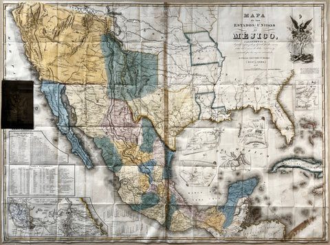
Mapa de los Estados Unidos de Mejico, segun lo organizado y definido por las varias actas del Congreso de dicha República: y construido por las mejores autoridades.
New York, 1850 (23rd Edition).
Engraved map with full original color.
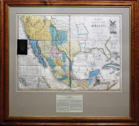
29 5/8” x 40 1/2” sheet, 50 1/2” x 54” framed.
The twenty-third, and penultimate, edition of Disturnelle's widely influential map, incorporating several revisions, including the addition of "Eagle Pass” in northern Coahuila and the substitution of “Sacramento City” for “Nueva Helvetia.” More an entrepreneur than a cartographer, Disturnell recognized that maps of Texas and the West would become popular items after the state was admitted to the Union in 1845, and the Mexican-American War made it an even more popular commodity. The demand for maps of the west by Americans increased with the outbreak of the Mexican War in 1846. This was reflected in the inclusion of Mexico on U. S. maps and in the publication of separate maps of Mexico with adjoining states of the Union. Particularly significant, because it was used in negotiating the peace treaty of Februar y 2, 1848, that brought the Mexican War to a close, was John Disturnelle's Map of the United States of Mexico. (Ristow).
Outbreak of the United States’ war with Mexico in 1846 resulted in Disturnell’s map becoming a highly successful enterprise. It received widespread acceptance as an authority for the geography of the greater Texas region, and Disturnell issued it in twenty-three separate editions between 1846 and 1858. Because it was the most available map of Mexico, it assumed a lasting place in history when Nicholas P. Trist, the American plenipotentiary, used Disturnell’s map in negotiating the Treaty of Guadalupe-Hidalgo, which ended the U.S.-Mexican War and extended the western boundary of the United States to the Pacific Ocean. Differences soon arose over the wording of the treaty vis-à-vis the actual depiction on Disturnell’s map of the Rio Grande and the position of the city of El Paso. The lands in question were particularly important to the prospective railroad route to California and its newly discovered gold mines, a controversy which resulted in the United States purchase in 1854 of the Gadsden Territory, which rounded out the new U.S. boundaries.
For various editions and commentary, see: Bauer Sale 118. Cartografía Histórica de Tamaulipas, pp. 23-24. La Cartografía y el territorio nacional, p. 38. Cohen, Mapping the West, pp. 142-144. Amon Carter Museum Exhibit, Crossroads of Empire (June 12-July 26, 1981) 40. Day, Maps of Texas, p. 44. Eberstadt, Texas 162:257. Francaviglia, Mapping and Imagination in the Great Basin: A Cartographic History, pp. 88-90: “Disturnell’s influential 1847 Mapa de los estados Unidos de Mejico [and Mitchell’s New Map of Texas, Oregon, and California] confirmed the Great Basin had become an icon.” Goetzmann, Army Exploration in the American West 1803-1863, pp. 156-157 (Chapter V, “The Boundary Survey”): “A notoriously erroneous map.” Goodwin, The Land that Became Texas, p. 244. Holliday Sale 299. Lombardo, Atlas histórico de la ciudad de México, plate 183. Martin, “United States Army Mapping in Texas...” in The Mapping of the American Southwest, p. 38. Martin & Martin, Contours of Discovery, p. 28.
Mapping Manifest Destiny: Chicago and the American West (Newberry Library exhibition), 3.8: “Despite its inaccuracies, Disturnell’s map looked authoritative.” Phillips, America, p. 410. Rebert, La Gran Línea: Mapping the United States-Mexico Boundary, 1849-1857, pp. 2-15. Reinhartz & Saxon, Mapping and Empire, pp. 157-158. Ristow, “John Disturnell’s Map of the United Mexican States,” in A la Carte, pp. 204-221. Rittenhouse, Disturnell’s Treaty Map, pp. 5, 15-18: “Few maps in United States history have had a role as interesting as that of the Disturnell Map—the map that was attached to the Treaty of Guadalupe Hidalgo at the end of the Mexican War in 1848.” Rumsey 2541 & 5175. Schwartz & Ehrenberg, Plate 170 & p. 276. Streeter Sale 254, 255, 256, 257, 278. Taliaferro, Cartographic Sources in the Rosenberg Library 283. Virga, Texas: Mapping the Lone Star State through History, pp. 42-43: “Reflects the still-changing face of the new state of Texas as it relates to its southern neighbors and the rest of the United States.” Wheat, Mapping the Transmississippi West 507, 540, 556, 606, 669; Vol. III, pp. 35-37, 45, 51-52, 77-78, 141. Wheat, Maps of the California Gold Region 33, 37, pp. 20 & 24.
The roots of Disturnell’s map go back to three earlier maps: Tanner, White-Gallaher-White, and Rosa. The earliest incarnation of this resounding map originated in 1822 when Philadelphia publisher Henry S. Tanner issued his Map of North America. Using the southwestern portion of that map, Tanner in 1825 published his Map of the United States of Mexico, which was printed from entirely new copper plates depicting only Mexico as it existed at the time. In 1826 he reissued the map with the Mexican border moved significantly to the north. In 1828, the New York firm of White, Gallaher and White published a map entitled Mapa de los Estados Unidos de Mexico that showed the Mexican border in the same position as it appeared on Tanner’s 1826 version. There is considerable disagreement on the relationship between Tanner’s 1826 map and the subsequent White, Gallaher and White map. Some authorities state that the latter plagiarized; others say that they merely copied. It would be disingenuous to say that White, Gallaher and White were completely unaware of Tanner’s map, but the former did go to the trouble and expense of providing a new map printed from new copper plates that showed a far wider area than Tanner’s map, although it did contain some of the same information, as the insets make quite obvious. White, Gallaher and White’s actual printing plates were subsequently acquired by New York publisher John Disturnell, who modified them by substituting his own name in the imprint area and in other ways. (White, Gallaher and White’s copyright notice is still faintly visible on this copy and most others in the lower right-hand corner just below the neat line.) The first issue of Disturnell’s map appeared in 1846, and numerous issues were put out by him until 1848, all printed from the same copper plates that underwent various modifications for each new issue.
Although widely known to be inaccurate, copies of Disturnell’s map were, nevertheless, used by the negotiators at the end of the Mexican-American War to set the boundary between the two countries. Because of major errors on the map involving the location of El Paso (present-day Ciudad Juárez) and the Rio Grande, a serious dispute arose about the parallel along which to run the actual boundary. After many surveyors and years, a line was finally run; it was, however, unsatisfactory to the United States because it ran too far north and left the prime area for the southern route of a transcontinental railroad in Mexico proper. Because of that location, the United States was obliged to buy the land from Mexico with the Gadsden Purchase.
Ristow, “John Disturnell’s Map of the United Mexican States,” in A la Carte, pp. 210-211: “The demand for maps of the west by Americans increased with the outbreak of the Mexican War in 1846. This was reflected in the inclusion of Mexico on U.S. maps and in the publication of separate maps of Mexico with adjoining states of the Union. Particularly significant, because it was used in negotiating the peace treaty of February 2, 1848, that brought the Mexican War to a close, was John Disturnell’s Map of the United States of Mexico.”
Ristow, American Maps and Map Makers, p. 451:
The man whose name is associated with this influential map, John Disturnell was a prolific publisher of popular handbooks, directories, gazetteers, statistical compilations, guidebooks, and maps. He capitalized on the growth and development of railway and steamship transportation, on the growing tide of immigration, and on the California Gold Rush.... Disturnell had no personal competence in mapmaking. In common with other commercial publishers of the day he drew upon all available published and unpublished cartographic sources to compile his maps. Plagiarism and pirating of information were accepted practices.... The haste to get a revised map in the hands of prospective purchasers did not permit verification of information, and errors and inaccuracies were numerous. Disturnell’s maps were no exception.... Notwithstanding its apparent shortcomings Disturnell’s Mapa de los Estados Unidos de Méjico was undoubtedly a popular and widely consulted map in 1847. It is not surprising, therefore, that it was selected as the official treaty map by the United States and Mexican negotiators.
Normally we think of historically important maps as ones that present an advance in geographical knowledge, or those that depict a region or correctly name a newly evolved political entity. Sometimes there are fascinating rogue maps outside these parameters, such as “California as an Island,” that gain their fame and importance because they are so wrong. The Disturnell Treaty Map is an example of the latter. Disturnell’s ubiquitous commercial map was used in negotiating the new boundaries of the United States and Mexico following the Mexican-American War and the Treaty of Guadalupe Hidalgo. That massive divvying up amounted to one of the largest real estate transaction thus far for the young, restless, and ambitious United States. To the two official copies of the Treaty were attached the Disturnell map, but the Mexican copy of the treaty had the twelfth edition of Disturnell’s map, and the United States had the seventh edition of the map. Both maps were faulty, resulting in a protracted re-negotiation of the Treaty, a contentious boundary survey, and a recognition by the United States of the importance of the pivotal role of the U.S. Army and the Corps of Engineers in the settlement, development, and “winning” of the West.
Due to the negotiations of the Treaty of Guadalupe Hidalgo and the faulty Disturnell maps, the United States insured its claim to Texas and gained the huge expanse of Northern Mexican territory that includes what are now the states of California, Nevada, Utah, with parts of Arizona, Colorado, New Mexico, Wyoming, Kansas, and Oklahoma. The United States acquired approximately 850,000 square miles of valuable territory (counting Texas), increasing its holdings by more than a third, and emerged as a world power in the late nineteenth century. Mexico, on the other hand, lost approximately half of its territory, including giving up its claim to Texas. The Treaty established a pattern of political and military inequality between the two countries, and this unbalanced relationship has stalked Mexican-U.S. relations ever since.