Arader Galleries
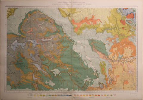
Hayden. Western Colorado and Part of Utah. 1881.
$ 675.00
Pickup currently unavailable
Ferdinand Vandeveer Hayden (1829–1887)
Western Colorado and Part of Utah
From Department of the Interior, United States Geological and Geographical Surveys of the Territories Atlas, Washington, D.C., 1881
Lithographed map
Sheet size: 37.5 x 26.5 inches
This map, created under the direction of Ferdinand Vandeveer Hayden, presents a detailed survey of western Colorado and part of Utah as part of the U.S. Geological and Geographical Surveys of the Territories. Compiled in 1881, it provides an intricate depiction of the region’s topography, highlighting mountain ranges, river systems, and key geographic features. Hayden’s surveys, commissioned by the Department of the Interior, were instrumental in advancing scientific understanding of the American West, particularly in the assessment of geological formations and natural resources.
At the time of this map’s publication, the American West was undergoing rapid transformation driven by railroads, mining expansion, and federal policies aimed at territorial consolidation. Colorado had recently achieved statehood in 1876, signaling its growing importance, while Utah remained a U.S. territory, still largely influenced by Mormon settlement and tensions between the federal government and the Church of Jesus Christ of Latter-day Saints. The completion of the transcontinental railroad in 1869 had already reshaped the region’s economy, increasing migration and development, while federal land policies and surveys like Hayden’s were paving the way for further resource extraction and settlement.
The map exemplifies the precise cartographic work of the late 19th century, combining scientific survey data with practical geographic insights crucial for exploration, settlement, and economic development. A significant document in the history of American cartography, it remains an important reference for scholars and collectors interested in the development of Colorado and Utah. Elegantly presented, this example is well-suited for display in collections focusing on Western exploration, geological surveys, and 19th-century American cartography.