Arader Galleries
MELISH, John (1771-1822) Map of the United States with the contiguous British and Spanish Possessions...1816
$ 120,000.00
Pickup currently unavailable
MELISH, John (1771-1822)
Map of the United States with the contiguous British and Spanish Possessions Complied from the latest & best Authorities
Copper plate engraving with original hand color
Philadelphia: James Finlayson, June 16th, 1816
43 ¼ x 56 ¾ inch sheet
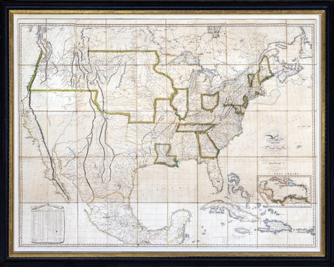
The second most important map in American history, juxtaposing for the first time the discoveries of Lewis and Clark, Zebulon Pike, Thomas Long, Thomas Nuttal and Andrew Ellicott. The first and most famous cartographic expression of “manifest destiny,” the map was a tempting invitation to Texas and a threat to Mexico. One of the most studied maps in America; research is available on request.
This landmark wall map, by John Melish, is highly coveted by collectors, as it is the first map to show the United States potentially stretching from the Atlantic to the Pacific, giving visual expression to the idea of “Manifest Destiny.” In the early 19th century, many Americans felt it was their mission to expand the borders of the United States westward for ideological, political and economic reasons. This map was published just as the notion of Manifest Destiny was crystallizing in the general American consciousness, and predicted the glorious fate that the young nation anticipated.
This grand map of the United States was also highly accurate and advanced in it's depiction of the geography of the United States, as it used information from the travel accounts of early 19th century explorers such as Zebulon Pike, Lewis and Clarke, Thomas Nuttall and William Darby. As Walter Ristow, a legendary American mapping historian, states of this map, “Melish played a foremost role in many and varied sources of the geographical and cartographical knowledge of the period, and presenting it systematically and graphical for the edification and enlightenment of the citizens of the voting republic.”
John Melish was a highly educated Scottish merchant who settled in Philadelphia in 1811, eventually to become one of the first great cartographers on the American continent. Melish drew on a number of official state maps to produce this mammoth map of the United States, which was used on several occasions to determine boundary lines between the United States and Mexico.
This is a highly coveted first printing from 1816 and was updated frequently over the following several years as new discoveries came to light. Melish died in 1822, and his plates were then used by James Finlayson to publish new states of the map in 1823. It is a classic in the history of American mapping.
John Melish's map of the United States is generally considered the single most important and influential map of America published in the 19th century and is rivaled only by John Mitchell's map of North America in 1755 as the single most influential map in American History.
Described by some scholars as the visual embodiment of Manifest Destiny to an American public searching for a graphic depiction of America's territorial acquisitions from coast to coast in the early 19th Century, Melish's map is a work of towering importance, being the first large map to incorporate the discoveries of Lewis & Clark, Alexander von Humboldt, Zebulon Pike and the early fur traders and explorers of the 19th Century into a large map of the United States. Over the next decade, it was the primary map utilized to depict and determine every important American Boundary Treaty of consequence and continued to be a source of determining boundary disputes until the end of the Century. During the remainder of Melish's lifetime, the map was meticulously revised and updated, with a total of 25 states of the map identified by scholars between 1816 and 1823.
Described by Thomas Jefferson as a luminous view of the comparative possessions of different powers in our America, Melish's map, first issued in 1816, was the first indigenous attempt to map the United States from coast to coast and synthesized the works of Lewis & Clark, Humboldt, Pike, Arrowsmith, and others for the first time, in a single large-format coast-to-coast mapping of the United States.
Much as Mitchell's map influenced boundary disputes and treaties in North America for nearly a century after its publication, the Melish map similarly became the essential source map for the 19th Century. It has been described by several commentators as the visual embodiment of Manifest Destiny to an American public searching for a graphic depiction of America's territorial acquisitions from coast to coast in the early 19th Century. Following the Louisiana Purchase, Americans turned their attention westward to the great expanse from the Mississippi River to the Pacific Ocean. While the explorations of Lewis & Clark and Zebulon Pike provided early regional snapshots of previously unknown regions in the West, it was left to Melish to tie together these works, along with Arrowsmith's map of Mexico and other available sources, into the first systematic and comprehensive map of the United States.
Prior to his map of the United States, Melish had produced a number of other highly acclaimed regional maps like his rare Military & Topographical Atlas of the United States. However, this map of the United States would become his masterwork, ultimately reissued in 25 known states of the map between 1816 and 1823.
The most notable advance in the later states of the map is the addition of an extra plate at the bottom of the map, which provided coverage of Cuba, Jamaica, the Virgin Islands and the remainder of the Gulf Coast and the Yucatan, to the map. The map, in its various editions, faithfully recorded the changing geography of the US, as various boundary disputes, treaties and explorations extended both the geographical territory of the US and a young nation's knowledge of its own territory. As noted below, the Adams-Onis Treaty of 1819 was laid out on a copy of this 1818 edition of the map.
Melish reportedly released only 100 copies of each edition. Because of the map's size and its use as an official source, relatively few copies have survived.