Arader Galleries
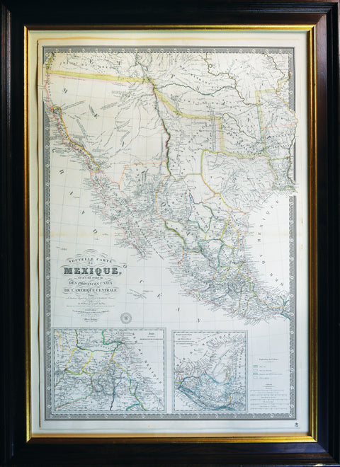
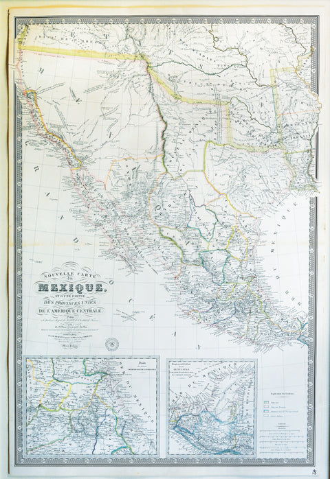
Brue. Nouvelle Carte du Mexique...1834
$ 22,000.00
Pickup currently unavailable
Mexique, Et D'une Partie des Provinces Unies De L'Amerique Centrale, Dediée á l'Acadamie Royale des Sciences de l'Institute de France.
Paris: Chez Ch. Picquet, 1834.
2 sheets joined (36 4/8 x 24 4/8 inches).
Provenance: with Altea (Massimo De Martini), London, 11/95; From the important cartographical library of Warren Heckrotte, his sale, Rare Cartography, Exploration and Voyages, Part II, December 3, 2015, Lot 105 (miscatalogued as being 1835)
"A monumental map, much on the order of the Arrowsmith and Wyld maps of the period" (Wheat)
A magnificent map showing Texas as a province, Upper California and Mexico, and of importance for showing Jedediah Smith's journey to California and back in 1826.
"In fact, a most important map of 1834 - historically speaking - was that of A.H. Brué, also published posthumously by his widow. It was a map of Mexico, beautifully engraved, as were all the maps of this cartographer. It... carries many of the legends of the 1833 Brué map. On this map, however, a line has been added from the Lac Teguayo (Lac Salé) area south to the R. Adams, thence southwest past the Rock Salt Cavern to the Seeds-Keeder River, and finally across to San Diego, the line being labeled in the north 'Route de Smith en 1826' and farther south merely 'Route de Smith'... All but one of the names mentioned by Jedediah Smith in his letter dated October 11, 1827... are present
on this map..." (Wheat 404)
The insets are:
Détails des environs De México et de la
Vera-Cruz Complement de la Carte donnant Le Yucatan et une partie des provinces unies de L'Amérique Centrale.
Adrien Hubert Brue’s "Nouvelle Carte du Mexique, Et D'une Partie des Provinces Unies De L'Amerique Centrale," published in Paris in 1834, represents a significant historical artifact, reflecting the geopolitical landscape of Mexico and Central America during a crucial period of transformation. The map, dedicated to the Royal Academy of Sciences of the Institute of France, offers not just a geographic representation of the region but also a window into the shifting political dynamics that characterized the early 19th century. This map is a product of post-colonial Latin America and European intellectual curiosity, illustrating the complexities of nation-building in the aftermath of independence.
One of the map’s primary historical significances lies in its depiction of post-independence Mexico and Central America. Mexico had recently gained its independence from Spain in 1821, and this map captures the early delineations of its national borders. The inclusion of part of Central America, referred to as the "Provinces Unies de L'Amérique Centrale" (United Provinces of Central America), further underscores the map’s importance. This federation, which existed from 1823 to 1839, comprised modern-day Guatemala, El Salvador, Honduras, Nicaragua, and Costa Rica. The map reflects a region in flux, where new nations were emerging from the vestiges of Spanish colonial rule. By charting the boundaries of these fledgling states, Brue’s map offers insight into the geopolitical realities of the time, before further territorial changes and conflicts would reshape the region.
The map also illustrates the enduring influence of European powers on Latin America, even after the collapse of colonial rule. Although Spain had lost its colonies, European interest in the region remained strong, and France, in particular, maintained a significant intellectual and cultural influence. Brue’s map, produced in Paris, is a testament to this continued engagement. It was dedicated to the Royal Academy of Sciences of the Institute of France, emphasizing the period’s commitment to scientific exploration and accuracy in cartography. French scholars and cartographers took a keen interest in documenting Latin American territories, and this map exemplifies that scholarly pursuit.
Furthermore, the map is historically important for its timing, as it predates several key geopolitical changes in Mexico. Published just two years before the Texas Revolution in 1836, which resulted in the eventual secession of Texas from Mexico, the map provides a snapshot of Mexican territorial boundaries before this significant loss. It also predates the U.S.-Mexican War (1846-1848), which would lead to further territorial concessions, including the ceding of vast lands to the United States under the Treaty of Guadalupe Hidalgo. Brue’s map, therefore, offers a visual representation of Mexico at a moment when its national borders were still largely intact, providing a valuable reference point for understanding the country’s territorial evolution.
Paris, a major hub for cartography in the 19th century, was the birthplace of this map, and it reflects the artistic and scientific precision for which French cartographers were known. Brue, a respected figure in the field, created maps that were both accurate and aesthetically pleasing, combining scientific rigor with artistic sensibility. The map’s dedication to the Royal Academy of Sciences highlights the connection between cartography and the broader scientific endeavors of the time, emphasizing the role of maps as tools for understanding the world.
In conclusion, Adrien Hubert Brue’s 1834 map of Mexico and Central America is a historically significant artifact that encapsulates a transformative period in Latin American history. It captures the early boundaries of newly independent nations, reflects the continued interest of European powers in the region, and offers a snapshot of Mexico’s territorial extent before further losses. Produced in Paris, this map stands as a testament to the skill and precision of 19th-century French cartographers and their contribution to the scientific and intellectual exploration of distant lands.