Arader Galleries
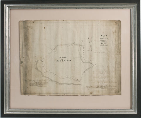
Emmons. A Manuscript Map of Saucelito. 1868
$ 24,000.00
Pickup currently unavailable
George Foster Emmons (1811-1884)
Exterior Boundary of the Town of Saucelito
1868
graphite, pen, and ink on paper
Framed: 18" x 24"
EMMONS, George Foster (1811 – 1884). Plat of the Exterior Boundary of the Town of Saucelito. 1868
Fine manuscript map, graphite, pen and ink on paper (18 x 24 inches, float-mounted and framed), of the boundary of the Town of Saucelito in California, with explanatory notes signed by Emmons lower left and right.
Provenance: Spring Valley Water Company, Leland Stanford and W.B .Bourne, presented as evidence at the California Supreme court -1917 SVWCo. VS SFPUC, with court stamp on verso
A fine manuscript map, based on one first drafted in 1849 by Captain William Richardson, and updated by Emmons, Commodore in the U.S. Navy and Chief Surveyor for the Wilkes Ex.Ex 1838-1843. Created for the Spring Valley Water Company, Leland Stanford and W.B Bourne, who used this example to sue the city of San Francisco in the California Supreme court -1917 SVWCo. VS SFPUC, and in the process established a state standard for comparable evaluation in real estate and the creation of the San Francisco public water authority. It is one of more than 1800 maps presented as evidence in SVWCo. vs SFPUC 1917 California supreme court case. The others were sold to Stanford University - John Branner Earth and Science Library in Palo Alto, CA in 2012-2013.
The Spring Valley Water Company appointed George Emmons to determine why their existing 1849 map of Sausalito by Richardson, and a survey of their lots there continued to fail to attain the proper outcome. Emmons was able to show that the variance for magnetic north of 16-19 degrees over 20 years created a dysfunctional map. In his notes on the map Emmons accounts for the northern variances along the northern boundary lines of this map in red ink.
Emmons was the primary surveyor of the American West under the Wilkes ExEx 1838-1843, a Mexican-American War hero, a Civil war Commander and Captain of the Ossipee when the U.S. signed over Alaska on board its decks in Sitka in 1867-1868. He had just returned to San Francisco Bay and been appointed Commodore of the Navy at the time this map was drafted.